Monthly Archives: April 2013

Day 12 – Sourton to Redruth

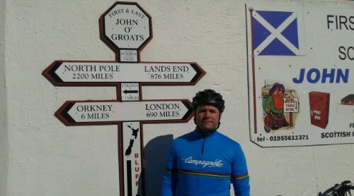
Today’s route avoided the busy A30 as much as possible. I cycled down some lovely, quiet country roads. There were plenty of ups and very fast downs, but nothing that my hardened legs couldn’t handle.

I have made it to Cornwall.

image

I think that today’s ride was one of the best I have ever had. The roads were good, the scenery was fantastic, and the weather was superb. My overall mood was great, in part due to my achilles hurting less (I raised my seat a little higher, which did the trick), but mostly because this was my last full day in the saddle, as I only have 30 miles left to cover until I reach Land’s End tomorrow.

I am staying in a campsite in a place called Wheal Peevor. Back in the day this area used to produce a lot of tin. Some old mines still remain, although the days of tin mining are well and truly over. This is what the mines look like.

image

As I write this, it seems a bit strange that my adventure is drawing to a close after nearly a fortnight trying to get from the north-east to the south-west on 2 wheels. Just one last effort to go…
Day 11 – Highbridge to Sourton

After decent food, decent beer and a decent sleep, I woke up feeling so much better after yesterday’s exertions. Today the sky was blue, the headwind had gone and the A38 was in much better shape.

Apart from my troublesome right achilles tendon (which has been sore for the past few days and is getting slowly more bruised and swollen) I felt great, and I made quick progress through Somerset and into Devon.

I stopped to eat my packed lunch on a bench in the grandly named village ‘Sampford Peverell’ and I soaked up the sun’s rays.

1367238149393

A little further on I passed by a lovely looking pub called ‘The Trout Inn’ which stood by the rive Exe in Bickleigh – but I didn’t stop.

There are definitely less flat bits to enjoy and more hills to get up and over in Devon. This tells me that I am getting closer to Cornwall, which is precisely where I will be tomorrow.

Hills = more energy needed to get up them, which is why I had this for dinner.

1367264163325

Day 10 – Gloucester to Highbridge

Today was a bit of a struggle. I started off well enough, but the middle 40 miles was really hard going. The A38 was in poor shape, I had a headwind to fight against and it was hilly. The worse bit was getting through a very busy Bristol. It seemed to take forever.

The scenery was also pretty dull, which matched the weather – it was cold with grey cloudy sky above.

I was really glad to finish. It took me 6 hrs 50 mins to ride 72 miles. Yesterday it took me 6 hrs 30 mins to ride 92 miles. That gives an indication of how difficult the conditions were today.

image

The day’s highlight was dinner at a pub near the campsite. I had steak and ale pie and 2 pints of ‘Old Speckled Hen.’ Very, very good.

Day 9 – Wem to Gloucester

I really enjoyed this morning’s ride. The roads were really good and all through Shrewsbury I followed decent cycle paths along the A49.

In fact everything was going well up to the really nice village of Church Stretton – and then my Garmin stopped working for some reason, so I had to use my paper map. Needless to say I missed a couple of turns, which added a few miles to the day’s total (92 miles today), but I didn’t mind as the weather was good and the roads were fast.

I passed by a Cadbury’s factory at Hope under Dinmore and the whole area smelt of chocolate brownies, which made me long for one or two.

image

A little further on from there I passed Hampton Court castle, which looked mighty impressive.

image

I cycled in 3 counties today. I started in Shropshire, then went through Hertfordshire and now I am in Gloucestershire. Tomorrow I will reach Somerset. If I am able I will try to check out Burnham-on-Sea, which I have heard is a nice place to visit.

This was hanging on the wall in the campsite’s washroom.

image

It reminded me to try and see if I can find a Somerset cider tomorrow.

Day 8 – Leyland to Wem

As I left the campsite this morning I spied this monster rig.

image

Now that belongs to a fella that likes to camp in style. The spray job on the trailer said ‘silverback’ so I will leave you to picture what he looks like.

Today’s ride was a fast 67 miles over mostly rolling countryside. Warrington was not so picturesque. The bit I went through reminded me of a long Purley Way (large retail outlets and industrial estates) but with the Warrington Wolves’ stadium plonked right in the middle of it.

I crossed into Shropshire and became aware that the roads and surroundings became a lot calmer, away from the A49. Next up was Whitchurch and then Wem, where I am staying the night.

I’m not too keen on my neighbours though.

image

Their field is right behind the motorhome – a ewe and her 2 lambs.

I’ve got a longer cycle tomorrow, just over 80 miles to Newent in Gloucestershire, and some hills to get over on the way. My legs feel up to the challenge, which is a good thing, as I will be in hilly Cornwall in a few days time.

Day 7 – Penrith to Leyland

I left the campsite this morning in light drizzle, but in good spirits. By the time I got to the beginning of the long climb up Shap Fell the drizzle had turned to rain, but I was still feeling good and I was looking forward to tackling it.

image

I managed the climb well. It went up gradually rather than having any significant steep bits. By the time I got to the top my lower half was wet through. I could feel my feet squelching around in my cycle shoes. My top half was ok as I had a rain jacket on. The very fast descent (40 mph) left me quite chilly and I realised that I needed to get warm quick as I still had some 60 odd miles to cover.

So, I asked myself, ‘what would Bear Grylls do if he was in my situation?’ I remembered him saying in one of his shows of the importance to get your feet dry, so I made a decision to seek out a clothing store when I got to Kendal. As I approached the town I hit the jackpot. I found a Morrisons superstore. Brilliant. They sell socks, nice dry socks, and towels to dry my feet with. So, with that in mind, I made my way there as quick as I could and made my purchases. They also had a cafe, so I had a hot lunch and I was able to dry myself out a bit.

By the time I left the rain had subsided, so I pressed on to Lancaster.

I really enjoyed today. The roads were in good shape and apart from Shap, they were not too steep. I got held up going through Preston during rush hour, but I soon got through the traffic.

I managed to cover 90 miles, but had only planned on riding 81. Where did the extra 9 come from…

Day 6 – Moffat to Penrith

I didn’t appreciate my alarm going off at 8:00 am this morning. I could’ve slept for at least another couple of hours. I also discovered that I have quite bad windburn on my face. Ouch.

The thought of a short day (64 miles) was all the motivation I needed to sort myself out and get back on the road, despite the grey clouds and drizzle. But there was one thing missing – the headwind. It had gone and what’s more it stayed gone all day.

Even though I was feeling the after effects of the past few days, I felt good today. Riding without a strong wind in my face is so much easier.

I made good progress down to Lockerbie, then Gretna – the first and last place in Scotland.

image

image

A few metres from this ye olde wedding venue and I was back in England – at last! Goodbye Scotland.

image

I then made my way through Carlisle and Penrith to Lowther Holiday Park. This place has 5 stars and I think I know why. It has a bath, and I had one. Hopefully it has soothed my leg muscles enough to tackle Shap Fell tomorrow morning. It will be a steep climb up and a very quick descent…

Day 5 – Kinross to Moffat

Today was a hard day in the saddle.

It started off lumpy through Kelty, Crossgates and Inverkeithing, then I had to get over the Forth Bridge.

It was windy, very windy. I got off my bike and took a photo looking across the Firth of Forth and I could feel the bridge vibrate beneath my feet. It was a very strange feeling.

Next up was Edinburgh. I picked my way through bike routes to the centre and stopped to eat my sandwich in the park opposite Murrayfield Stadium.

image

Out towards Penicuik the terrain was up and down and yet again I had to fight a strong headwind, which slowed my progress.

I picked up the A701, which led me all the way to Moffat, some 40 odd miles through amazing scenic countryside. Often I found myself totally alone with no-one in sight. It felt very remote in some places.

image

The wind and the constant climbing got to me at times, but the last 5 miles were downhill all the way. This saved me as I was beginning to flag a bit after 8 hrs 43 mins on the bike and 88 miles to add to the tally.

Tomorrow will be my last day in Scotland. Land’s End is getting nearer…

Day 4 – Newtonmore to Kinross

I got up early today and cleaned my bike, to get the accumulated road grime of the last 203 miles off, then I oiled the chain, pumped up the tyres and I made my way to the cycle path which ran alongside this part of the A9.

But, as soon as I turned right, out of the campsite, I was hit by a strong headwind – this didn’t bode well. Then, a mile later, it started to rain and cycling into it hurt my face.

image

The weather really started to close in as I slowly approached Dalwhinnie. In the first 2 hours I only covered 12 miles. This was painfully slow, painfully windy and the rain was painful. This was not fun.

But, as soon as I went past the Drumochter Pass (summit is 1508 feet) the weather dramatically improved and so did the roads, as they went downhill pretty much for the next 20 miles. This was just what I needed to lift my spirits and from then on I had a brilliant ride. Now this was what I was hoping my end to end would be like.

Roll on tomorrow and see what the day brings.

Day 3 – Dingwall to Newtonmore

The mighty Ross County FC.

image

What an unexpectedly long day. I originally planned to cycle 70 miles down quiet A and B roads to avoid the A9.

My plan started well enough and I had a great morning. The sun was out. The wind had died down and I was really enjoying it.

Then just before I reached Kessock Bridge my Garmin ran out of power. I had forgotten to charge it the night before. Disaster. There was no way that I’d manage to navigate the quiet roads to the campsite now. I had to rely on my printed route to give me an idea which way to go.

I paid the price for my schoolboy error as I ended up cycling an extra 17 miles, having taken a few wrong turnings.

I even went as far as Culloden, which I didn’t intend to.

image

I eventually rolled into the campsite at 7:30 after cycling 86 miles.

I was in need of a hot meal. The problem was there was no restaurant nearby. The campsite is in the middle of nowhere. It is very scenic in this part of the Cairngorms, but there is no food here. Dinner was cheese and corned beef sandwiches and cheese and onion crisps. Hopefully things will be better tomorrow.